C. RESIDUAL SOIL DEPOSITS
The focus of this section is the weathering of rock masses to develop residual soils. These soils form a large class that are not deposited through a geological transport process. Weathering of the upper 1/3 to 2/3 meter of soil ( A, B or C horizons ) will only be included as it pertains to engineering properties. They do not normally play a large role in the transport of subsurface contaminants and can and are often easily removed in remediation schemes. Weathering of constructed landfill covers will be left to that module.
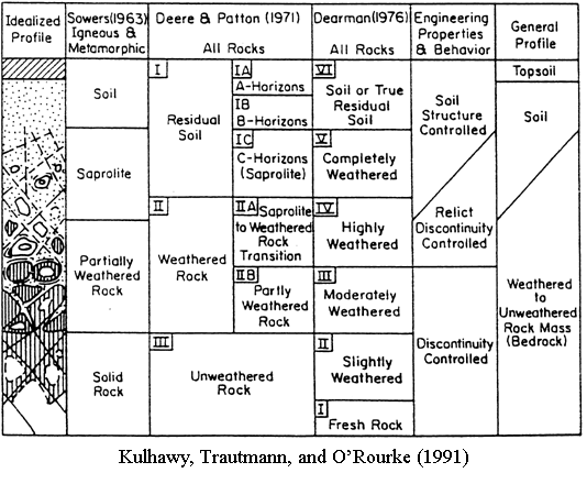
I. Weathering Profiles
A. As shown in Figure
C1, weathering profiles grade from the agricultural A,B & C horizons
through saprolite (soil with relict rock structure) to decreasingly weathered
rock.
B. Weathering is intensified at the rock joints where water interaction
is the greatest.
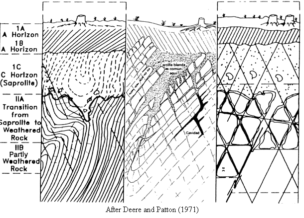
C. Horizontal variability is extreme as shown in Figure
C2 for weathered, metamorphic rock,
limestone, and intrusive igneous rock
D. Auto correlation distances in the weathered zone would be very small,
single meters, and
depend upon rock type.
E. Depths to moderately weathered rock are important. They should be determined
with
1. more borings and fewer lab tests
2. auger boring resistance
3. seismic shear wave velocities
F. The anaglyph of Sink Hole Topography in the Sedimentary Rock section
illustrates the
large horizontal and vertical variability of residual soils over dissolved
limestone
II. Character Is Dependent upon Rock Type
A. Sedimentary
1.Limestone
a. highly variable as shown in Figure
C2 (middle profile)
b. deepest weathered soil profiles of what is left after limestone has
dissolved
c. up to 20 to 30 m in humid climates
2. Sandstone
a. can weather highly along joints; otherwise not highly variable
b. moderately deep,
c. less than 6 m in Georgia
3. Shale
a. relatively invariable
b. shallow weathering because joints swell and prevent entrance of water
c. less than 1 - 3 m
B. Igneous
a. can be variable if extrusive (see basalt flow example)
b. moderately deeply weathering especially with high
ferro-magnesian mineral content (See Figure
C2, right profile)
c. ferro-magneisan minerals oxidize relatively easily
d. less than 20 m in piedmont
C. Metamorphic Rock
a. depends upon rock type
b. quartzite: like sandstone only more so
c. gneiss: like granite
d. schist: more weatherable than granite (See Figure
C2, left profile)
highly variable
2 to 20 m within 60m horizontally
III. Engineering Properties
A. permeability
Usually the lower "C" horizon is the most permeable
B. Stability
Orientation of weathered zone is important as shown in Figure
C3
Water flows through "C" and leads to instability of material above
C. Excavation
Variability leads to complex payment schemes
D. Deformability
1. Normally as deformable as the weakest portion, the residual soil.
2. Exploration difficult because soil-like material may exist below unweathered
rock
core stones
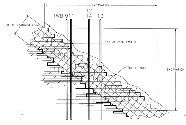
IV. Example of weathered rock properties on slope
A. Five borings taken within 6 m of each other shown in Figure
C4
to determine weather boring 9 was "representative"
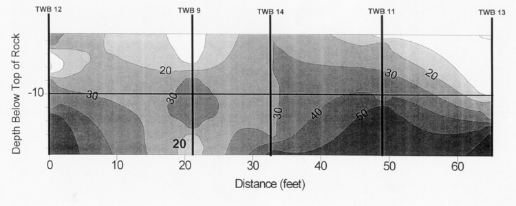
B.
Figure
C5 shows RQD variation of 9 vs. the average +/- one standard deviation
of the 4 borings
C. RQD increases with depth below top of rock as defined where
casing could not be advanced without drilling. On average 9 shows worse
rock
D.
Figure
C6 shows a fence diagram of RQD vs. depth below top of rock
E. High variability of weathered rock was confirmed